Laboratory for the simulation of climate, environmental, ecological, Earth and space weather systems, to predict climate and environment variability, prevent and mitigate natural disasters more effectively.
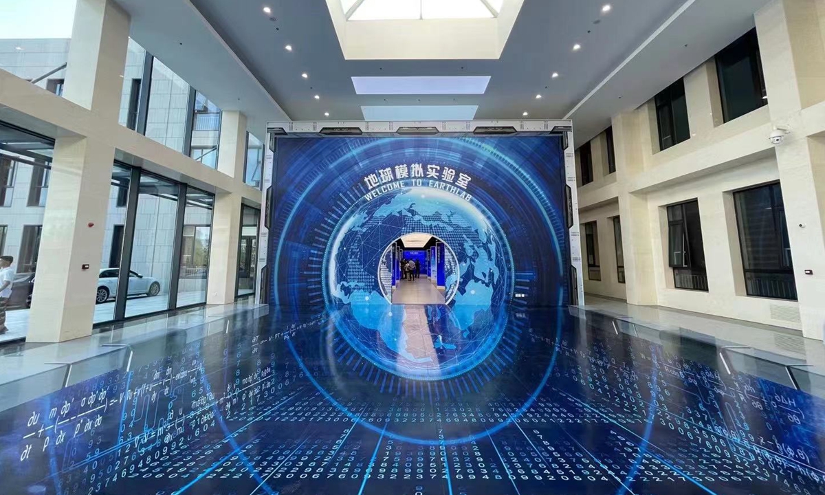
The virtual EarthLab was officially launched on 23 June 2021 in Beijing’s Huairou Science City on Wednesday. In partnership with Tsinghua University, the Institute of Atmospheric Physics at the Chinese Academy of Sciences (CAS) began developing EarthLab in 2018. After trial operations, inspections and approvals, EarthLab is expected to become fully operational — and open to universities and research institutes across the world — in 2022, according to the CAS.
The project will improve China’s right to speak in international climate negotiations.
Statement by Chinese Academy of Sciences
The Earth is a sphere, and it comprises other spheres: atmosphere, hydrosphere, cryosphere, lithosphere and biosphere—in short, all of the cycles that interact to influence Earth’s weather and climate. Now, to better research how the spheres interact and impact the planet, China is launching EarthLab in Beijing. On June 23, after EarthLab’s opening ceremony, researchers will begin trials to demonstrate the facility’s ability to integrate simulations and observations to more accurately project outcomes and provide a scientific foundation to predict and mitigate such things as natural weather disasters.
EarthLab’s research team published an introduction to the facility on June 23 in Advances in Atmospheric Sciences.
“Since the earth system is extremely large and complex, traditional theories and observations are too limited to meet the overall requirements of the scientific research community,” said paper corresponding author He Zhang, EarthLab researcher affiliated with the Institute of Atmospheric Physics (IAP) at the Chinese Academy of Sciences (CAS). “EarthLab is the first comprehensive virtual earth laboratory in China for simulation the physical climate system, environmental system, ecological system, solid earth system, and space weather system as a whole with a high-performance scientific computing platform.”
In partnership with Tsinghua University, IAP/CAS began construction of EarthLab in 2018. After successful trialing, inspections and approvals, EarthLab is expected to become fully operational—and open to universities and research institutes across the world—in 2022.
“Other countries, such as the United States and Japan, as well as some European countries, have built specialized numerical simulations facilities,” Zhang said, noting that China’s vast and complex topography has been difficult to model accurately with various levels of observational and experimental resources across the country. “Weather, climate and environmental disasters occur frequently and seriously with grave losses of life and property. Consequently, a global earth system simulation system, as well as high-precision regional environmental simulation system, are urgently needed to better predict climate and environment variability, to prevent and mitigate natural disasters more effectively, and to formulate relevant national plans more scientifically.”

According to Zhang, EarthLab will also become a science outreach base for children and students to learn more about Earth sciences. During an IAP outreach day in 2017, children voted on EarthLab’s Chinese name: Huan. The name means “a place as vast as the earth where people live and upon whose land they depend.”
“Our ultimate goal is to predict Earth systems on a vast range of time scale, from seconds to hundreds of years, and of spatial scale, from 10 meters to millions of meters,” Zhang said. “Along with other earth simulators around the world, the development and construction of EarthLab will advance not only the understanding of the Earth’s spheres and their interactions, and Earth’s past, present and future, but also the progress of computational mathematics, high-performance computing and technology, and other broader fields.”
Sources: Physics Org, and Global Times, June 23, 2021 03
https://phys.org/news/2021-06-china-earthlab-trials-country-facility.html
https://www.globaltimes.cn/page/202106/1226872.shtml
More information: Zhaoyang Chai et al, China’s EarthLab—Forefront of Earth System Simulation Research, Advances in Atmospheric Sciences (2021). DOI: 10.1007/s00376-021-1175-y
Journal information: Advances in Atmospheric Sciences
______________________________________________________________________________________________________________________________
Explore further: Data from China’s Fengyun meteorological satellites available to global Earth system science applications
In APRIL 2021, the Chinese Academy of Sciences also announced:
Data from China’s Fengyun meteorological satellites available to global Earth system science applications
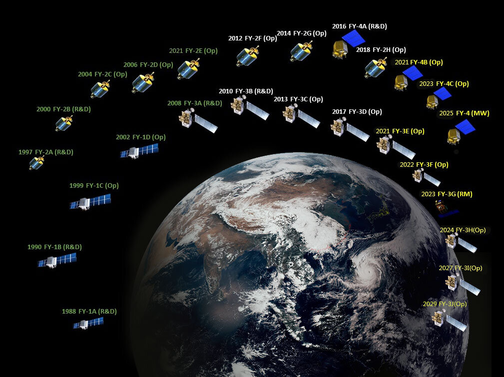
Many meteorological satellite networks are constantly scanning Earth, providing vital research data and real-time, life-saving weather information. Since China began its initial development in 1970, the Fengyun (FY) series of meteorological satellites have advanced considerably throughout more than 50 years. While FY satellites primarily focus on the atmosphere, they are capable of observing complex variables within the Earth-atmosphere system. Since the initial FY dispatch, China has successfully launched 17 FY satellites, seven of which are currently operating in orbit.
The Fengyun Meteorological Satellite Ground Application System generates more than 90 Earth observation products every day, producing more than 10TB of daily data volume. The FY Satellite Data Center has continuously stored Earth observation data, beginning when FY-1A successfully launched in 1988, to today. More than 12PB of archived satellite data exists in the database through more than 30 years.
“Several approaches for FY satellite data access have been developed for real-time users, scientific researchers, and public users.” said Dr. Peng Zhang, the deputy director of National Satellite Meteorological Center of China Meteorological Administration. “All FY satellite data products are open to the world users and free to download.”
Dr. Zhang is also the corresponding author of a data description article recently published in Advances in Atmospheric Sciences. The article showcases FY data products used to observe wildfires, lightning, vegetation indices, aerosol products, soil moisture, and precipitation estimation. All of these metrics have been validated with in-situ observations and have been cross referenced with other well-known satellite products.
The European Centre for Medium-Range Weather Forecasts (ECMWF) and weather forecasting agencies in China have assimilated the wide array of FY data into many numerical weather prediction (NWP) models. Since the 1990s, coupled meteorological satellites and numerical models have changed the way scientists understand the Earth. As numerical weather prediction and Earth system models continue to evolve, meteorological satellites will play a more important role in the future of Earth sciences.
“FY is included in the World Meteorological Organization’s global operational meteorological satellite sequence. It provides data and products to more than 110 countries and regions as well as 2,700 broadcasting users.” Dr. Zhang added. “We have been working with scientists from ECMWF, UK MetOffice, and other countries to improve data verification and application. We welcome scientists and forecasters all over the world to use FY data.”
Source: Physics Org, 29 April 2021
https://phys.org/news/2021-04-china-fengyun-meteorological-satellites-global.html